Tag Archives: backpacking

West Coast Trail Day Four

Friday, 31 July 2015. Carmanah Creek to Camper Bay. 16km or 10 miles

Carmanah Camp Morning

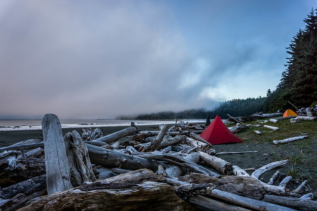
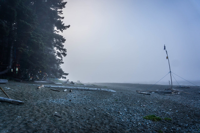
Yes, Carmanah was foggy once again, and this time, I had a bulk of my clothing still damp from laundry the night before, including my one(!) pair of hiking pants.  There were not too many campers at Carmanah that evening – DD and I counted some six groups there, which made the campsite seem relatively uncrowded in comparison with some of the other campsites we’d seen and experienced.

Continue reading

Share

West Coast Trail Day Three

Ditidaht Nation Campsite

Thursday, 30 July 2015. Tsuquadra Point to Carmanah Creek. 16km or 10 miles.

It was damp at the Ditidaht Campsite. So damp that not one piece of the laundry we did the night before dried. But it was going to be another slow morning, as DD wanted to take his time, explore, and let our things give up a little more of their moisture. Thankfully, the sun was cooperating that morning.

The night before, our hosts had warned us of the “mice problem” at the campsite, and they had allowed us to hang our food bags on the hooks of an open shed next to their cottage. Apparently they do not have bear problems and therefore bear boxes were uneccesary. Sometime in early morning, I heard a tiny scuffling noise, and opened my eyes to see a small form clambering along the outside of our tent, inside the rain fly, but still outside our shelter. With a cry, I batted it away, murmured “mouseykins” sleepily to DD’s “what? what’s wrong?!” and fell back asleep almost immediately.

Continue reading

Share

West Coast Trail Day Two

Foggy Morning at Darling River 

Wednesday, 29 July 2015. Darling River to Tsuquadra Point

We woke to fog coming off the sea. We took our time that morning, drinking coffee, making breakfast – this morning it was cheesy grits and ham – a perfect savoury meal made with Bob’s Red Mill Grits, simple dehyrdrated deli ham, and some generous tablespoonfuls of dehydrated milk and cheese. DD especially wanted to explore the tidepools exposed by low tide. I did not go out as far, fearing that my $2 Japanese rubber slippers, rubber nothwithstanding, might not be a match for the slippery, wet rocks strewn with seaweed.

Continue reading

Share

West Coast Trail Day One

Where Darling River meets the Ocean

Tuesday, 28 July 2015. Victoria to Pachena Bay; then Pachena to Darling River, 8.7 miles.

The alarm went off at 5:15am, so we could take our last showers before our 6-day trek in the wilderness. 6 Days with 2 outfits, 2 pairs of underwear (DD brought 3, which made me jealous), 2 pairs of socks and sock liners.

Royal Scot Hotel Room 

We also made hotel coffee, and slurped down some Shin Ramyun ramen we had found at the 7-11 the night before. Continue reading

Share

West Coast Trail Day Zero

View from Clipper Ferry

Our day of travel began by arriving at SFO in time for our early 7:30am flight. With priority status from splurging on First Class (using points), we checked our backpacks at the Virgin America luggage counter and breezed through security since we both also had TSA Pre. We got to our gate comfortably with thirty minutes to spare, but unfortunately our flight was delayed for about an hour.

When we reached Seattle, we then had to wait in a very long line and for what seemed to be an inordinate amount of time for a taxi. Not sure what was going on, but it seemed that Uber/ other ride sharing services was still prohibited from operating at the Seattle airport. Continue reading

Share

West Coast Trail Planning

West Coast Trail Vancouver Island 

When I proposed that we spend our 10-year anniversary of being together at the Willows Inn on Lummi Island, DD jumped at the chance to say “Well, why don’t we also hike the West Coast Trail?” The West Coast Trail, as it turns out, is a 75 km, 47 mile trail on Vancouver Island that brings trekkers through a meandering path of rainforest and beach, with various types of terrain – boardwalks, mud, fallen trees, boulders, rocks, soft sand, firm sandstone, and ladders. Lots of ladders, apparently. Continue reading

Share

Rae Lakes Loop Recap and Random Thoughts

One of the Last Bridges

Some last thoughts about my first-ever backpacking trip/ visit to a National Park…

Planning/ reservations

Jared handled all of our reservations to obtain our permit, which is required during peak season – May 22 to Sept 26. Not only should you make a reservation in advance, but you also need to pick up your physical permit at your starting trailhead before you embark on your hike. There is a limit of 25 people/ day to hike either clockwise or counterclockwise, and 3/4 of those reservations are able to be made in advance. The rest are available as day-of walk-ups. My friends Justin and Stephanie were able to get a walk-up permit on 4th of July weekend last year. We were lucky to make and get our reservations for a clockwise loop well in advance – early May for our late June trip. Make sure to pick the correct entry trail for the direction you wish to go in. Going clockwise, your entry trail is Wood’s Creek; counter-clockwise, the entry is Bubb’s Creek.

Here is the helpful trip planner from SEKI, but you may want to peruse their Rae Lakes Loop info page first.

Continue reading

Share

Rae Lakes Loop Day Four

Roaring creeks make me happy

Bubb’s Creek by our last campsite at Junction Meadow

Friday, 26 June 2015. Junction Meadow to Road’s End, 8,400 to 5,035 feet. 10.4 miles. 

I didn’t take too many photos on this day, perhaps because we were all hustling and ready to be done with the hike. Visions of showers danced in our heads.

We woke to overcast skies and a certain mugginess in the air. We were a little nervous that it might start raining, so out came our rain gear and backpack covers to reside in the most accessible areas of our backpacks.

Continue reading

Share

Rae Lakes Loop Day Three

The View from Glen Pass at nearly 12,000 feet

Thursday, 25 June, 2015. Rae Lakes, Summiting Glen Pass, Junction Meadow, 10,800 to 11,978 elevation, and back down to 8,400 feet. 8.6 miles. 

We rose late again on Day 3. I woke with a dull headache, which I initially chalked up to sleeping poorly with a badly-stuffed pillow (Zpacks Cuben Fiber stuffsack filled with clothing). Breakfast was the chicken jook that was Danny’s idea  — even reconstituted it was fantastic: chickeny and gingery and topped with bits of sweet-salty pork fluff.

The trail up to Glen Pass would take us around 1,900 feet in elevation gain to a summit of 11,978 all in the space of 2.8 miles. We left Rae Lakes around 9:15am, intending to take it relatively easy, with lots of breaks.

Continue reading

Share

Rae Lakes Loop Day Two

Wood’s Creek Trail. Photo by Jared Williams

Wednesday, 24 June, 2015. Upper Paradise to Rae Lakes, 6876 to 10538 ft in elevation gain, 11-12 miles. 

We left camp a little later than the day before at around 8:15am. In contrast to yesterday’s 7am start, it seemed very late, and it was already quite warm. A group of girls who had camped (but very quietly) at the campsite south of us had already left. We chatted with a couple of them yesterday and learned that they had made their way up to the lakes, but, at 10,000 feet, one of their group had gotten altitude sickness and they were compelled to turn back.

Continue reading

Related Posts Plugin for WordPress, Blogger...
Share