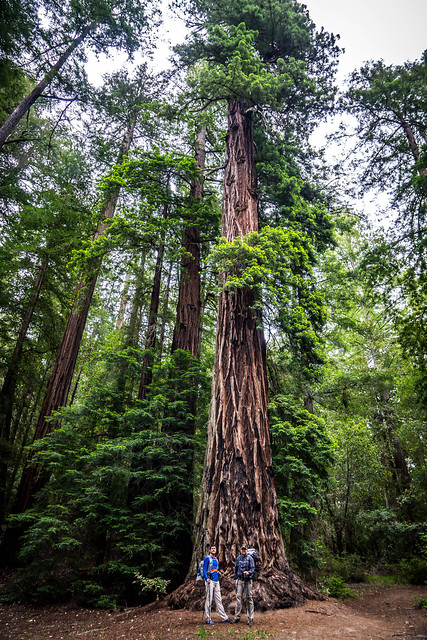
I’d always wanted to get to the Skyline to the Sea trail. Just a month earlier, Justin and DD and trekked 27 miles of it, successfully and quickly, in just a teeny bit over 8 hours. I had peeked at the various trail runs and races out there, notably the Coastal 50k/ Marathon and Pacific Coast Trail Runs races of the same distances, and dreamed of signing up for one of those longer distances someday.
So when my friend Christina pinged us to see if DD and I would be interested in a backpacking trip along the trail, I of course accepted eagerly.
Logistics
Reservations. Though Christina handled the whole process, it seems pretty straightforward. If you want to camp in any of the backcountry campsites, you’ll want to call for reservations 2 months in advance, on the first of the month. So, with Christina targetting a May trip, she called the Big Basin (lots of info here) camps reservation number at 9am on March 1st and got her first choice for the weekend of 20th-22nd of May.
You’ll have to decide in advance if you want to do a 2 night or 1 night trip. We opted to do 2 nights – in retrospect, DD and I could have done a 1-nighter, but taking our time and hanging out with good friends sounded appealing as well.
The distances between campsites indicated by this park-published PDF is not so accurate (later on we would find out that the signs along the trail are also woefully inaccurate) but basically the hike is around 10 or so miles a day, if you’re on the 2-night, 3-day schedule.
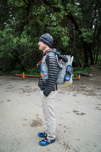
Food. I was initially torn between bringing my bear can and going light. DD was practicing carrying as little as possible, perhaps in preparation for a long-distance flashpack, and was toting a 20-Litre Montane pack. He not only opted out of bringing a bear can, but he also counted on bringing just barely a days’ worth of food, counting on getting his Saturday lunch, dinner and possibly Sunday’s breakfast at Big Basin HQ on Day 2. I ended up eschewing the Bear Vault, and just brought a Loksak and my Zpacks food bag. Night 1 the food came into our tents with us (no animal mishaps to report); Night 2 they went into the bear boxes stationed at Jay Camp. Mountain House meals seem to be the tastiest, and not as fussy as Packit Gourmet’s.
Maps/ Route. We ended up bringing the National Geographic’s Trails Illustrated Maps of Big Basin/ Santa Cruz. The ones I ordered from Mountain Parks Foundation (Sempervirens Fund’s Maps #1 and #2) were left at home since they would have required us carrying 2 maps instead of 1. The map we should have obtained, was probably Redwood Hikes Press’s Big Basin and Castle Rock map, which in one map contains the entire Skyline to the Sea trail.
The route is fairly straightforward but we followed Redwood Hikes’s directions from Castle Rock until we hit Skyline to the Sea.
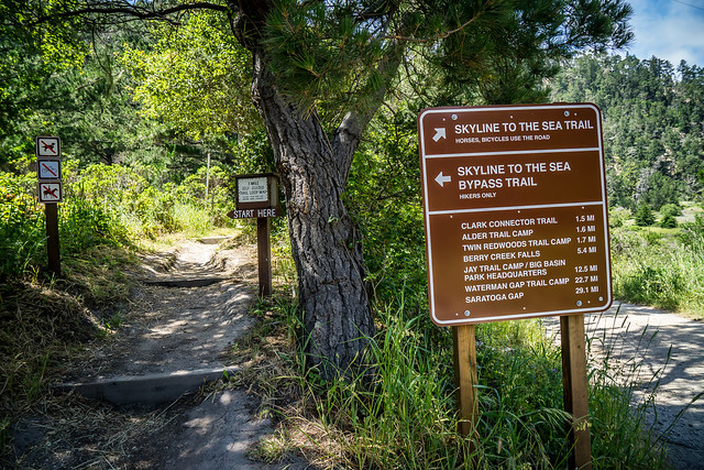
As mentioned above note that the mileage quoted on the various trail signs are not reliable. Here, the sign at the end of our hike, indicates that Big Basin HQ is about 12.5 miles away. Nope. Just around 10, according to our Runkeeper data…
Shuttling/ Transportation. Your reservation includes parking for one vehicle at a State Park parking lot. We parked at Castle Rock and Jared used the complimentary parking pass on his Honda. For our car, DD and I used an Annual State Park parking pass from one of our donations (to Golden Gate Park National Conservancy). There was some trepidation that it was only ok for day parking but when we returned to our car on Sunday, nothing seemed amiss and we had no tickets on the dashboard. Caiti had to purchase an additional $8 parking pass and we all had to display our permits in our vehicles. If we had chosen to shuttle, we could have parked another car at Rancho del Oso, near Waddell Beach. Overnight parking there is $10.
There are no pay phones or internet/mobile service at Waddell Beach. You will need to use the pay phone at Rancho del Oso to call a taxi if you’re so inclined. We called Yellow Cab, and ended up paying $170 ($140 fare, plus $30 tip) (somehow all five of us fit in one car) back to Castle Rock.
Our other plan was to catch the 5:15pm Santa Cruz Metro #40 bus, which picks up at Waddell Beach and drops you off 30 minutes later at the Santa Cruz Metro Center. There, we could call an Uber to drive us back to Castle Rock.
Internet/ Mobile Service. None to be had at Castle Rock or at Waddell Beach. There is very strong signal for both AT&T and Verizon at Waterman Gap, and middling Verizon signal at Big Basin HQ.
Gear Reflections
- Our Zpacks Duplex tent is roomy (we were able to stash all our gear in the tent itself!) and we are quite happy with it.
- I was comfortable in my ZPacks 30-degree sleeping bag/ quilt – I’ve learned to cinch up the neck, and slept with my Black Rock beanie, but my neck got cold on occasion. When I got I ended up ordering the Zpacks Goose Down Hood, like DD’s.
- I still need to figure out what to do about my feet, which tend to run cold. Perhaps I’ll just wear extra socks.
- I need to soak my camp clothing in Permethrin again.
- My Brooks Cascadias are holding up well. These are likely my shoe of choice for the JMT.
- White coloured pants show dirt very well. They also show ticks well, so I’ll likely be using these for the JMT, too. Thankfully, no ticks appeared on this particular trip.
- I used my new Anker Powecore 10000 mAh charger. At 6.4 oz it weighs 2-3 oz. less than my other 2 chargers. Didn’t seem to make a dent in its full capacity for phone and camera over 3 days.
Miscellaneous
Pingback: Skyline to Sea Day 3 | Legs, Engage!()
Pingback: Skyline to the Sea Day 2 | Legs, Engage!()
Pingback: Skyline to the Sea Day 1 | Legs, Engage!()